Monday, June 25, 2007

Lightning Safety

(Photos by Ben Chapman, Chickamauga, GA)


This week is Lightning Safety Awareness Week. There is no better time of year to discuss lightning than during the Summer. Lightning is often called the underrated killer. Tornadoes and hurricanes tend to grab the headlines with destruction and injuries, but lightning on average injures or kills more people each year. In fact, the odds of you being struck by lightning are far greater than you experiencing a tornado. Lightning carries an enormous electrical charge than can heat the surrounding air to over 5 times the temperature of the sun. That rapid heating and cooling of the air causes a crackling noise that we call "thunder". So, when it comes to lightning safety remember this rhyme, "When thunder roars, go indoors".

A good safety rule for lightning is the "30/30 Rule". The first "30" means that you should wait 30 minutes since the last visible lightning strike or clap of thunder heard before resuming an outdoor activity. Many area swimming pools and golf courses wisely use this rule, and you should at home as well. It does not have to be raining for lightning to occur. The charge build up is between the cloud and objects on the earth's surface. The other "30" in the rule refers to "seconds". Since light travels faster than sound, we see a lightning strike before the thunder is heard. Depending on your distance from the lightning strike will determine how much of delay will occur before you hear the thunder. When you see a lightning strike, begin counting 1...2...3, etc. For every 5 seconds that you count between the lightning strike and clap of thunder, it represents 1 mile in distance. So, if you are able to count 10 seconds between strike and thunder clap, the strike was 2 miles away. If you are able to count to "30" between the strike and clap, then the lightning strike was a safe 6 miles away. So, if you can determine that there is a 30 second or greater delay in strike to clap, it will be safe to go back outside.

Seeking shelter outside is also very tricky. You should never seek shelter under a tree or tall free standing object. Inside your car is very safe as long as the windows are rolled up. If you are ever stuck outside with no shelter available, then your best option is to drop to the ground with your arms and legs tuck together. This will make you lower to the ground and a smaller "target". When inside, stay away from windows. Power down certain electronic items that do not have a surge protector. Also, avoid a bath or shower during a thunderstorm.

There is an often quoted phrase, "Lightning Never Strikes Twice". That is a total MYTH! The Empire State Building in New York City is struck numerous times each year. And, the same can be said for many tall objects even here in the Tennessee Valley. Please take some time to go over these safety tips with your family. Even though we are in the midst of a drought, we tend to have a greater number of thunderstorms during the summer months.

Playing the role of Myth-buster again, here is another misunderstood lightning term...."Heat Lightning". Heat Lightning is nothing more than a visible strike of lightning from a thunderstorm that is too far away for the thunder to be heard.

Be sure to check out this web link from NOAA for more information about lightning safety (Link)

Friday, June 22, 2007

Weekend Getaways


The weather pattern should remain hot and dry through the weekend. A few pop up showers are possible, but only in isolated areas and mountainous terrain to the east. So, to get your mind off of the drought, which is not easy, a change of scenery might do the trick. Take a picnic or a hike in one of the beautiful state and national parks in our local region. Here is just a sample of what is in our own backyard.


Cherohala Skyway (Link)

Prentice Cooper State Forest (Link)

Little River Canyon National Preserve (Link)

Fall Creek Falls State Park (Link)

Savage Gulf/Cumberland State park (Link)

Amicalola Falls State Park (Link)

Great Smoky Mountains National park (Link)


Both the Cherohala Skyway and Smoky Mounatins National Park offer picnic spots at elevations of 5000 ft and above. It's a great way to beat the heat as temperatures above this level will hover below 80 degrees.


Don't forget to check out the Storm Track 9 7 Day forecast and Live Super Doppler before you head outside. Have a safe weekend!!!!

Thursday, June 21, 2007

Happy Summer Solstice!


Summer officially arrived at 2:06pm....although, really it has felt like summer the past few weeks. Spring 2007 was a strange one indeed with record freezes in April and an extension of the current drought. Summer 2007 should continue hot and dry to begin with, but hopefully into the peak tropical season starting in August we can see a reversal of the current weather situation.


Temperatures reached the 90s on the first afternoon of Summer, but the last sunrise of Spring had some cool temperatures around the Tennessee valley. Here is a sample of Thursday morning's temperatures (Normal Low: 66):
Murphy, NC: 52

Crossville, TN: 53

Ft Payne, AL: 53

Dalton, GA: 59

Chattanooga: 61

Check out these temps from the Smoky Mtns for Thursday morning:

Mt LeConte (6400ft): 37


Newfound Gap (5000ft TN/NC border): 49


Both morning and afternoon temperatures should begin to go up over the next few days. An increase in humidity will also allow for a few pop up showers across our region over the weekend. However, only a small portion of our viewing area will see the showers. There is still no sign of any large scale chance of rain like we experienced on Tuesday. So, the drought rolls on and we could pass the 16 inch mark below normal by early next week. Here are some local stories regarding the drought form area newspapers and news outlets:


NPR story about Tennesse's drought and stunted crops: (Web Link)


Northwest Georgia Drought Update: (Web Link)


Drought Affecting Trout Stocks in Georgia: (Web Link)


Drought Affecting Road Construction in Dekalb County, AL: (Web Link)


Fines for Illegal Watering in Metro Atlanta: (Web Link)

Monday, June 18, 2007

Drought Effects on the Tennessee River

Barbara Martocci of the Communications staff at TVA sent out this very informative article about the effects of our drought on the Tennessee River system. No doubt, if you were on our local rivers and lakes this weekend, these effects will sound familiar. This drought is reaching levels they we have not seen locally in quite some time. The full length article is listed below.


Effects of Dry Weather on the
Tennessee River System
The five-month period from January through May of 2007 was the driest such period in 118 years. Average rainfall in the Tennessee Valley above Chattanooga has been only 11.6 inches or 51 percent of normal.
Exposed shoreline and sandbars will impact boaters this summer due to the continuing dry conditions.
The long-term forecast is for continued dry conditions.
Since February, TVA has been operating the river system in conservation mode releasing only enough water to provide the minimum flow needed to protect water quality and meet other water-supply needs. This is to ensure as much water as possible is available to fill reservoirs to recreation target levels, as well as to provide other benefits Valley citizens have come to depend on.
Because of the dry conditions, most tributary reservoirs are significantly below their recreation target levels, typically met on June 1. On average, reservoirs in the eastern Tennessee Valley were about 10 feet below where TVA would like them to be by June 1.
Although water levels are low, they are nowhere near the driest historical levels. There are two reasons for this:
1) Operating the river system in conservation mode.
2) TVA changed its operating policy in 2004 to allow increased winter reservoir levels on most tributary projects. This change allowed more water to be in the reservoirs at the start of 2007.
Runoff the water that reaches the river after a rainfall is less in the spring and summer months when growing plants absorb more water. Thus, less water reaches the river system.
At this point, it would take several sustained, soaking rains the kind usually seen only when the Valley experiences the remnants of a summer hurricane to raise tributary reservoirs significantly.
Some effects that reservoir users will see as the dry weather continues are described below. More information, including current reservoir water levels, predicted levels for the next three days and observed rainfall and runoff, is available at www.tva.com/river.
Recreation
As water levels on the tributary reservoirs remain lower than normal, boaters may encounter more hazards. Sandbars could be exposed, and tree stumps could be closer to the surface.
Some boat docks may be in much shallower water or dry.
It is possible that users of tributary reservoirs will continue to see the mud flats that are typical during winter reservoir drawdowns throughout the summer.
TVA is continuing to review water availability in reservoirs with flow commitments for whitewater recreation. Recreation releases on the Hiwassee River were reduced for several weeks but returned to normal last weekend. At this time, TVA does not anticipate further reductions in recreation releases.
Water quality
TVA is providing water flows below dams to maintain water quality and protect aquatic habitat.
These minimum flows will continue to be maintained. However, this means that more water will have to be released from the already lower-than-normal upstream reservoirs.
Dissolved oxygen, necessary for aquatic life, is being monitored on the reservoirs throughout the river system. Due to low water flows, dissolved oxygen amounts are lower than normal on some reservoirs. TVA is examining opportunities for special dam operations that might help improve conditions on a reservoir-by-reservoir basis, but options appear very limited with so little water available.
Prolonged continuous low flows could cause cumulative water-quality impacts in mid to late summer.
Water supply
Although TVA operations have no effect on groundwater, localities and individuals that depend on groundwater (wells) and springs for water supply may be at increased risk for impacts to water supply due to the ongoing dry weather and continuing drops in the water table.
TVA is continuing to manage river flows to keep water levels above municipal and industrial water-intake structures.
Due to increased demands placed on municipal water-treatment systems, some municipalities with limited treatment capacity are asking customers to conserve water to ensure there is adequate treated water to go around during the ongoing drought conditions.
A number of states also are urging voluntary conservation or mandatory restriction in water use. Some municipalities have asked citizens to conserve water use to ensure there is enough water for the rest of the summer.
TVA is facilitating weekly teleconferences with representatives from state and federal agencies to discuss current drought conditions and anticipated impacts and to coordinate mitigation measures.
Hydropower generation
Hydropower generation has been reduced significantly due to the dry conditions.
TVA is generating as much power as possible with the water released to meet minimum flow requirements, but due to the low rainfall, hydropower generation for January through May was only 54 percent of normal.
Hydropower is TVA’s cheapest source of electricity generation. TVA may need to purchase more expensive power from other power suppliers if the hot, dry weather continues.
Navigation
To date, commercial navigation on the Tennessee River system has not been affected significantly by the dry conditions.
Water levels in the main Tennessee River are near normal levels as TVA continues to meet the flow commitments adopted as a result of the Reservoir Operations Study.
TVA is working closely with both the U.S. Army Corps of Engineers and the towing industry to identify and address potential navigation issues on the Tennessee, Cumberland and lower Ohio rivers associated with the continued dry weather.
Contributed by Barbara Martocci, Communications

Thursday, June 14, 2007

"Exceptional" Drought Status Spreads into Local Region


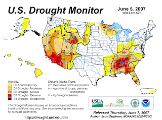
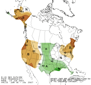
If you read my blog daily, you might remember that North Alabama achieved a distinction that it would like to lose last week. That region fell under the "Exceptional" Drought status, the highest drought category. Now, most of our viewing area in Tennessee and Georgia has been placed in that category. The Drought Outlook (Left Image), does not have any better news as the current drought conditions could persist locally.

Severe storms struck locally on Thursday and produced large hail and wind damage. Here is a list of storm reports from Thursday from the Storm Prediction Center:

Hail Reports:

Etowah, TN: Quarter Size Hail
Sweetwater, TN: Quarter Size Hail (Accumulated 3 Inches on the ground, Fog resulted from melting)

Wind Damage:

Benton, TN: Trees and Power Lines Down
Grandview, TN (Rhea County): Trees Down

Wednesday, June 13, 2007

Drought Rolls On......Beating The Riverbend Heat!

The drought continues to dominate local headlines as the "ripple" effect from this dry spell begins to settle in. Area farmers have been feeling the effects since winter and the continued lack of rain has only made things worse. The overall pattern the next 5 to 7 days still only has pop-up or scattered variety of showers with Friday being a slightly more favorable day.

Some cool temperatures early Wednesday morning around the Tennessee Valley:

Murphy, NC: 51
Ft Payne, AL: 55
Dalton, GA: 55
Crossville, TN: 55
Chattanooga: 61

Local Weather Headlines:
Rhea County Drought Update: (link)
Jack Daniels vs Drought (link)

With Riverbend in full swing, here are some safety tips to beat the heat, while you dance in the streets.
Early evening temperatures should be in the middle 80s Wednesday through Saturday. With sunset not until around 9pm, the first few hours could be quite toasty. Here is what you can do to stay cool:
- Drink plenty of water to stay hydrated
- Wear lightweight/light colored clothing
- A hat can help shield you from the early evening sun
Should a thunderstorm move over the festival area you will need to seek shelter from lightning. The safest place will be back at your car. Never seek shelter under a tree or other freestanding object. Be sure to wait 30 minutes after the last visible lightning strike before going back outside. Remember, it does not have to be raining for lightning to occur.
The Storm Track 9 Team will be providing weather updates at the festival site before each of the nightly headliners. We will provide a live look at the Storm Track 9 Super Doppler and a look ahead to the next days forecast.
Have a fun, but safe time at Riverbend 2007!

Storm Track 9 Live Super Doppler (link)
Storm Track 9 WebCast (link)
Storm Track 9 Live Neighborhood Net (link)

Monday, June 11, 2007

Drought Reaches "Exceptional" Level


In previous postings, I have reported the current level of drought as indicated by the US Drought Monitor. During April and May, our region progressively worsened from a "severe drought" to an "extreme drought". Most of our viewing area remains under an "extreme drought" category. But, over most of the Tennessee Valley region in north Alabama, the level of drought has reached to highest (or worst) category of drought...."exceptional". Jackson and DeKalb Counties are included in this area of drought.

A couple of days of rain will certainly be welcome, but it will take a long term pattern of consistent rainfall to turn around the drought. As I have stated before, an active tropical season in the Gulf can serve to break down the persistent, dry ridge of high pressure that has dominated the US Southeast's weather. Landfalling storms sometimes have a hard time getting this far inland, but occasionally can provide us a soaking. But, the "moist" pattern that results can provide a more consistent pattern of rain locally. August and September are the more active months for tropical activity.

In the short term, the 6-10 day outlook does have a large portion of the Southeast in a slightly above normal category for rainfall, but most of that will be to our south.

Tuesday, June 5, 2007

Drought Is The Talk Of The Town

It is an unpopular subject, but one that will no doubt pop up in most conversations across the Tennessee Valley. Of course, I am talking about the drought. Many folks have emailed or called me to desribe their lawns (or lack of). I had a gentleman from Trenton tell me that his lawn looked like a desert. My lawn is not any better. By the time I had finished mowing the lawn last weekend, I was covered in layers of dust. I looked a lot like the Peanuts character "Pig Pen". I'm sure all of us have a personal story to tell of our local conditions. Rain would solve the problem, but it's just not that simple with our current weather pattern. A weakening front should move our way by late Friday which could generate some scattered showers late Friday afternoon and evening, but only in a few spots. A late day shower or two is also possible Saturday and early next week. Granted, it is better than no chance of rain at all, but because the rain only falls in isolated areas, it does little to help the regional drought. Please read some of my earlier blog entries about why I feel a busy tropical season could help us, and why the drought could lead to hotter temperatures.

Local Web Headlines: Local Golfers Affected By The Drought (link)
East Tennessee Drought Update (link)
Wildfires in the Cherokee National Forest (link)

Monday, June 4, 2007

Hotter Days Ahead


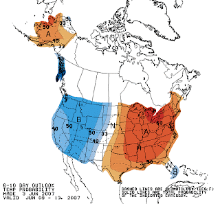
Hopefully many of you were fortunate enough to have had a few showers water your lawn over the weekend. My lawn was not one of them. Nearly 40% of our local region experienced showers Sunday and a few were rough in Monroe County. A few pop up showers are still possible through Wednesday, but the coverage is only 20%, the other 80% of us will still be dry. As a ridge of high pressure builds in from the west late this week, it will signify the beginning of another lengthy dry period. At the same time, temperatures will be rising and reaching the 90s beginning late this week and through the weekend. The next 6 to 10 days has us in a region of well above normal temperatures and below normal rainfall.

Friday, June 1, 2007

Weekend Showers Possible......Barry Soaking Florida


As expected, pop up afternoon showers have returned and the chance should exist each afternoon through Monday. The best coverage will be Sunday and Monday. You can view our Storm Track 9 Live Super Doppler at the following link: Live Super Doppler. Be sure to also view our latest Webcast for an update on how long the showers will last (link). After Monday, the chance of scattered pop up showers should drop once again, and temperatures will rapidly heat up for the middle and late part of next week.


Meantime, the disturbance in the southern Gulf was upgraded to Tropical Storm Barry Friday, but was downgraded to a Tropical Depression as it moved ashore along the west coast of Florida. On the first day of the 2007 hurricane season, the 2nd name on the list has been used. Barry should not strengthen much because of the westerly wind shear over the western Gulf. This should "kick" Barry rapidy to the northeast across the peninsula of Florida Saturday afternoon. It will bring some much needed rain to the Florida peninsula. Then, the remnant low pressure system should spread rain over the fire ravaged areas of south Georgia, then to South Carolina. Unfortunately, the Tennessee Valley will not see any significant rainfall from Barry.