Tuesday, July 31, 2007

TD3 Becomes Tropical Storm Chantal...No Threat to U.S.


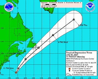
Chantal is no threat to the U.S. It is moving rapidly northeast as it is being absorbed by a cold front. Chantal should begin to lose its tropical characteristics and become "extratropical". Even though it will not be "tropical", it will still gain a little strength as it passes off the coast of Newfoundland and across the north Atlantic. This storm will be a menace to shipping through the end of the week and the weekend. The National Hurricane Center has issued the last advisories on Chantal as of 11pm Tuesday.

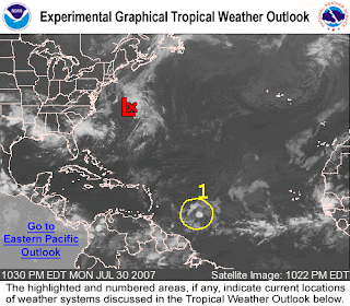
Another area being watched for possible development is a tropical wave east of the Windward Islands. The system remained disorganized Tuesday, but environmental conditions appear favorable for future development. Hurricane Hunter aircraft is scheduled to investigate this system, if necessary Wednesday.

A non tropical low pressure system is off the Carolina coast, and should remain offshore as it moves northeast.

Monday, July 30, 2007

Tropics Starting to Stir


It comes as no surprise that activity is beginning to stir in the tropical regions of the western Atlantic. As i mentioned in my post from last week, the start of August signals the start of the busier time of year for tropical weather. There are two features being watched. The first is Tropical Depression 3 east of Bermuda. It is an area of low pressure which has slowly become more organized. Its window of opportunity for development to a tropical storm is starting to close as this low should get absorbed by a cold front and get shoved rapidly northeast off the US coast. It could affect the Canadian Maritimes as a tropical storm. The second area to watch is a tropical wave that is getting better organized a couple of hundred miles east of the Lesser Antilles. Computer model guidance is suggesting a general west-northwest movement as it moves into the warm waters of the Caribbean Sea. Some further development is possible.

Sunday, July 29, 2007

Record Breaking Rainfall Saturday

2.74 inches of rain was recorded at Lovell Field in Chattanooga on Saturday. That total now stands as a record for the most rain received for a July 28th. The record rainfall also boosted our monthly rainfall total for July to 7.18 inches, which is 2.86 inches above normal for the month. We still have a huge deficit for the year, but it has been whittled away to 12.23 inches. However, since June 1, we have experienced above normal rainfall with 9.20 inches received. that total is 0.89 inches above normal. July has been a terrific start to the second half of the year concerning rainfall.

Wednesday, July 25, 2007

Hurricane Season Has Only Just Begun!


Hurricane season begins every year on June 1. But, the "real" hurricane season really kicks off August 1. If a hurricane season was compared to an NFL season, we would still only be in the preseason. I spent the last 8 hurricane seasons on the Alabama/Florida Gulf coast. I was able to forecast and experience some of the most destructive hurricanes in US history (Ivan and Katrina). Granted, we did have a few early season hurricanes in June and July (Dennis in 2005), but the true meat of the season gets underway after August 1. I have already seen a few national news reports that are a little premature and impatient with their reporting claiming that the 2007 hurricane season is a bust. The hurricane season is a long way from being over, and here are some stats to drive home this point.
During an "average" hurricane season, the first named storm usually occurs by July 10. For 2007, we are already ahead of schedule with Tropical Storm Andrea occuring in May and Tropical Storm Barry on June 1-2. The first hurricane of an average season should occur by August 14th, which is still 3 weeks away. The first major hurricane of an average season typically occurs by September 3rd (6 weeks from now). The statistical peak of the season is not until September 10th. So, as these statistics show, its way to early to call the 2007 season a bust. The extremely busy 2004 season really did not get cranked up until the second week of August with Bonnie and Charley hitting Florida just 2 days apart.
The available heat potential in the Gulf is above normal, but lower in the western Atlantic. So, the Gulf coast has conditions which are ripe for sustaining a developed storm should one move into the Gulf basin. The position of the Bermuda High off the US east coast is providing an alley way which still tends to favor Florida and the central/eastern Gulf for tropical activity.
So, as the "preseason" ends and the busy part of the season kicks off, you can depend on the Storm Track 9 team to keep you posted of storms that could affect your beach plans and those that could have some local impact.

Interesting Editorial from the Wall Street Journal written by hurricane expert Dr. William Gray - (Link)

Tuesday, July 24, 2007

August Outlook


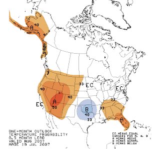
Another round of showers has kept our July rainfall total above normal. If this trend continues for the next 7 days, it would mark the first month of 2007 to have rainfall above normal. As I mentioned in yesterday's blog, it is a very nice and welcomed change to the second half of 2007. So, what's in store for August? Will this trend continue? The Climate Prediction Center recently issued its temperature and rainfall outlook for August. The Tennessee Valley region is placed in the "Equal Chances" category for temperatures which indicates that our average temperature for the month could have equal chances of being "normal", "above normal" or "below normal".....A confusing signal, right? Well, if you look on the map, you will notice that most of the southeastern US will be in the "above" normal category. So, I would venture to say that our local temperatures should average near or slightly above normal for August. As for rainfall, the CPC places our region again in the "equal chance" category with most of Florida in the "above normal" range. As I have stated in many past postings, the true peak of the hurricane season begins to arrive during August and then especially Septmeber. A more active season along the southern coasts could result in a near to above normal rainfall pattern. So, it will be interesting to see what transpires in the tropics over the next few weeks.

Tomorrow's Topic: The "Real" Hurricane Season is About To Begin!

Monday, July 23, 2007

July 2007 Cooler & Wetter So Far

After a warmer and drier start to the first half of 2007, the second half is off to a totally different trend. The first 3 weeks of July have been both cooler and slightly wetter than normal....that's right, "wetter" than normal! Through July 23rd, the official total at Lovell Field is 3.76 inches which is 0.17 above the normal total of 3.59 inches. The average temperature through July 23rd is 78.1 degrees, which is 1.3 degrees cooler than normal. We have experienced several mornings with lows in the lower 60s. August is just around the corner, so some of the hottest conditions of the summer "should" be on the horizon. I just hope that our trend of near to above normal rainfall will continue. Based on some long term trends and outlooks for August, we should be near normal for rainfall.

Tuesday, July 17, 2007

2007 Mid-Year Global Weather Update from NOAA

As we enter the 2nd half of 2007, it will come as no surprise to most of us that 2007 has been warmer and drier. Late June and July have given us some hope that a "wetter" pattern might stick around for a while. Actually, July has been near normal for rainfall, and below normal for temperatures during the first half of the month. NOAA issued a press release Tuesday that gives us an update of the US and global weather stats for the first half of 2007. Here is the full text of the press release:

2007 WARMER, DRIER THAN AVERAGE FOR MUCH OF U.S.,
GLOBAL AVERAGE TEMPERATURE SECOND WARMEST ON RECORD SINCE JANUARY

Warmer- and drier-than-average conditions
dominated much of the United States during the
first half of 2007, according to scientists at
NOAA's National Climatic Data Center in
Asheville, N.C. The lack of precipitation led to
widespread drought, which triggered an early
start to the wildfire season, mounting crop
losses and local drought emergencies. However,
drought in the southern and central Plains gave
way to heavy and persistent rains which led to
devastating flooding from Texas to Kansas in
June. Meanwhile, the global average temperature
was the second warmest on record for the January-June six-month period.

U.S. Temperature Highlights
- For the contiguous United States, the first
half of 2007 was the 18th warmest January-June
since records began in 1895. The six-month mean
temperature was 1.3° F (0.7° C) above the 20th
century average of 48.4° F (9.1° C).
- Temperatures were much warmer than average from
the mid-Atlantic and Midwest to the northern
Plains and throughout the West. In the contiguous
U.S. only Texas was cooler than average, while
near-average temperatures were widespread across
the South and Northeast. Alaska was 0.3° F (0.2°
C) below the 1971-2000 mean for the January-June period.

- June 2007 was the 23rd warmest June on record,
1.4° F (0.8° C) above the 20th century average of
69.3° F. The warmer-than-average June
temperature helped increase residential energy
needs for the nation. Using the Residential
Energy Demand Temperature Index (REDTI - an index
developed at NOAA to relate energy usage to
climate), the nation's residential energy demand
was approximately 1.5 percent higher than what
would have occurred under average climate conditions for the month.
U.S. Precipitation Highlights
- The year began with widespread severe drought
in the southern and central Plains, Wyoming, the
western High Plains, and northern Minnesota.
Above average precipitation helped ease or end
drought in many of these areas by mid year, but
this was not enough to overcome an extremely dry
winter and spring throughout most of the West.
Meanwhile, much-below-average precipitation
caused drought to develop in the Deep South.
- Four of the first six months of the year were
wetter, or much wetter, than average in Texas,
Oklahoma and Kansas. The wet period was
punctuated by heavy and persistent rains in June
that produced devastating flooding in the region
and the continued threat of flooding into early
July. Monthly rainfall totals exceeded one foot in some locations.
- Much of the West and the South suffered from
extreme drought conditions brought about by
months of below average precipitation.

- An extremely low winter and spring snowpack
throughout the West combined with above average
temperatures in the spring and early summer set
the stage for an early start to the wildfire season.
- It was the second driest January-June and
driest April-June on record in the Southeast. By
the end of June, 65 percent of the region was in
drought. Alabama was hardest hit, with 86 percent
of the state's pasture and range lands in poor --
or very poor -- condition in early July,
according to the U.S. Department of Agriculture.
The entire state was declared a drought disaster area.

Global Highlights
- The combined global land and ocean surface
temperature was the second warmest on record for
the January-June six-month period. Separately,
the global January-June land-surface temperature
was warmest on record, while the ocean-surface
temperature was the sixth warmest in the 128-year period of record.

- For June, the combined global land and ocean
surface temperature was the fourth warmest on
record as neutral El Nino/Southern Oscillation
(ENSO) conditions contributed to an overall lower global ranking for the month.

- Above average temperatures covered much of the
world's land surfaces during the first half of
the year. While some land areas in the Southern
Hemisphere began the June-August winter season
with below average temperatures, it was the
warmest June on record at the South Pole.

Friday, July 13, 2007

Normal July Weather Returns

We have had a nice break from the oppresive heat and humidity over the past two days. For the weekend though it is back to a typical July pattern. This means that we can expect hot and humid days with a daily round of afternoon t-showers beginning Sunday. Most of next week should be hot and muggy with afternoon t-showers each day...overall typical for July. Please be sure to check out all of the weather features that we offer on our web page which includes :
Video Webcast
Live Super Doppler
7-Day Forecast
Live Neighborhood Net

Have a terrific, but very safe weekend!!!!

Thursday, July 12, 2007

Weekend Outlook

What a start Thursday morning! As expected, temperatures dropped into the lower 60s which allowed us to have a break from the oppresive heat and humidity that is typical for this time of year. Here is a sample of some low temperatures from around the region:
Robbinsville, NC: 57
Crossville, TN: 58
Murphy, NC: 59
Dalton, GA: 62
Ft Payne, AL: 64
(Newfound Gap TN/NC border 5000ft: 52)
We should have another nice morning Friday as temperatures once again dip to the 50s on the mountain tops and low/mid 60s in the vallies. Clouds should continue to stream in through Friday morning. We should see the return of some scattered showers late Friday morning and through the afternoon, but this should be a quick rainfall event. For the upcoming weekend, expect a return to a typical July pattern. This means higher humidity and a daily chance of mainly afternoon t-showers (especially Sunday). Afternoon highs should return to near 90 and muggier mornings near 70 degrees. An unsettled weather pattern should be in place for next week which means that we can expect a hot and humid pattern with a daily round of t-showers.

Tuesday, July 10, 2007

Break Out The Umbrellas!


Yes, it's time to get out the umbrellas!!! A slow moving cold front should push our way late Wednesday. In advance of the front, there is abundant moisture in place which should result in numerous showers and thunderstorms area wide through most of the day Wednesday. A few storms could be severe, so you can depend on the Storm Track 9 team to keep you posted of any watches or warnings that might be issued. Don't forget to check out our Live Super Doppler throughout the day. Some parts of the Tennessee Valley could receive well over an inch of rain from Wednesday's showers (see above image). Parts of north Alabama could even received upwards of 2 inches or more. We are still in the midst of an extreme drought, but each rainy episode does help chip away at the huge deficit. The latest US Drought Monitor results can be seen on the second map above.

After Wednesday, we should get a nice break from the high humidity. Sunshine should return for Thursday with afternoon readings heating back up into the lower 90s. A slight chance of showers could occur Friday, but drier conditions should return to kick off the weekend on Saturday.


Taking a break from weather. You might be wondering why there is a photo of a cat on today's blog. My family and I had to say goodbye to a very dear friend yesterday. Our 14 year old cat, "Oxford" lost his battle with kidney disease. Most of us may not realize how our pets do become members of our family. My wife and I took in Oxford as an 8 week old stray when we lived in Chattanooga back in 1993. Our 2 sons born in 1995 and 1996 never knew a day without Oxford. In fact, when most of our friends would ask us about our children, they would also ask about Oxford. Everybody who visited our homes both in Chattanooga and Mobile knew
Oxford. We have 3 other stray pets that we have given shelter at our house, but there will never be another Oxford. There are many other strays that need homes. Please support your local animal shelters and other groups that help find homes for stray cats and dogs.

Tuesday, July 3, 2007

90 Day Outlook...Any Relief?


Over the past week, our weather pattern was a little more generous with rainfall. During the one week span from June 25th to July 2nd, the official rainfall total recorded at the airport was 1.79 inches. Before last week, it had taken from May 5th to June 24th (49 days) for us to receive a similar total of 1.83 inches. So, have we finally turned the corner? The answer is sort of a "yes" and "no" answer.

Yes, we are finally seeing the afternoon showers and storms that are so common in the Tennessee Valley and Southeast during the summer. Some areas received far greater totals than the airport over the past week, but some localized spots did not receive much at all. So, the overall drought continues because of the extent of our rainfall deficit and the sporadic nature of the rainfall received. At the very least, our lawns are greener!

The "no" answer to a pattern change is simply because of the fact that the rainfall we have seen is scattered in nature. The overall pattern for the next 8-14 days still indicates a similar pattern of scattered daily showers, but no uniform chance of rain that everyone shares in equally. So, this will at least slow down the expansion of the drought and only slowly chip away at the deficit.

As I have mentioned on many occasions in this blog, the key to our hopes of rain lies within the peak of the hurricane season. Granted, the tropics have been quiet since June 3rd and that has made some news headlines because of it. However, June and July are typically quieter months in the tropics. August through October is the true meat of the season with September 10th the peak day of the hurricane season. So, there is quite a way to go! An active tropical season around the northern Gulf coast can help create a weather pattern more conducive for sustained periods of rain even as far inland as the Tennessee Valley. And, should a landfalling storm
make it as far north as Chattanooga, heavier rain can result. We have experienced this in the past with such storms as Hurricane Ivan (2004), Hurricane Opal (1995) and even Hurricane Eloise (1975)...all northern Gulf coast storms. I certainly do not wish for a major hurricane strike on the already battered Gulf coast, let me make that perfectly clear. But weaker storms and mild tropical storms can provide a similar "wet" scenario to the Southeast and Tennessee Valley, so this would be the scenario we need to look for.

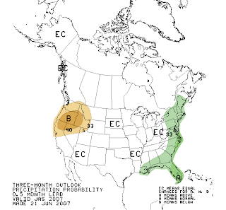
The new 90 day outlook for temperature and rainfall has been released by the Climate Prediction Center. The temperature outlook keeps us in a possible above normal category through the end of September. The rainfall outlook keeps the Tennessee Valley below normal. However, the above normal category surrounds the Gulf and southeast Atlantic coast indicating that an above normal tropical season is still expected as the peak of the season arrives. So, I still believe that this will be the key to our region finally seeing a turn around if we are to reverse this drought. Only time will tell!