Monday, October 15, 2007

StormTrack 9's New Blog Location!


I want to thank everyone for reading the StormTrack 9 Blog at its current web location. Starting October 16th, a newly revamped Newschannel 9 web page will be unveiled. We are very excited about this, and I am sure you will be pleased to see the new layout and content of our web page. I have been striving to make the StormTrack 9 Blog and all of the weather content on our web page to be the best web site for local weather. With our new website and blog that commitment will continue. So, please update you Favorite's List and join us on the new Newschannel web page at www.newschannel9.com.

Wednesday, October 10, 2007

NOAA Winter Forecast Issued....La Nina = Warmer


With the first Fall chill on its way, NOAA is trying to warm things up with its release of the 2007-2008 Winter outlook. Their forecast is no surprise based on the La Nina conditions in the eastern Pacific. A large part of the country including the Tennessee Valley is expected to have warmer than normal temperatures (typical for a La Nina pattern). The Tennessee Valley is right on the borderline of being just above normal for rainfall and below normal. So, it could go either way. A few days ago I posted some research that I did on the local effects of La Nina. Overall, it usually does mean warmer than normal conditions for the season, but there will be some cold spells mixed in. Here is a reprint of that research:

La Nina is a global pattern that results from the cooling of the ocean water off the coast of South America. It is just the opposite of the El Nino pattern of warm water in the same region. The upwelling of water in the equatorial region off the South American coast leads to this effect. Now, El Nino and La Nina episodes are nothing new, both have been occurring at alternate periods for centuries. However, with each episode we are learning more about the global ramifications that take place. In simplest terms, a La Nina pattern usually equals mild and dry winters in the U.S. and increased hurricane activity in the western Atlantic. El Nino episodes usually relate to wetter patterns over the southern U.S and slightly decreased hurricane activity in the tropical breeding grounds of the Atlantic. Now, that is a broad scale view of the two patterns. With a developing La Nina, here is some research on how our local weather has been effected by past La Nina episodes.

I took a look at La Nina episodes that have occurred since 1980 and there were 5 of them. The most recent was in 2000-2001. Other years include, in order: '83-'84, '88-'89, '95-'96, '98-'99 and '00-'01. Each set of years had some differences as would be expected. But, there were some similarities. I will start with tropical weather. With the exception of '83-'84, each La Nina set of years had above normal tropical activity late in the season (mid Sept-November). The average was 4 September storms, 3 October storms and 1 November storm. There was also an average of at least 2 major hurricanes during the late part of the season. As for our local conditions during the time frame of October-March, here is what I found. Octobers were warmer and drier than normal. Novembers had near normal temperatures and above normal rainfall (yipee!). The December's during these years were quite interesting. Decembers average below normal for temperatures and slightly above normal for rainfall/snowfall. Snowfalls of 2.3 inches (2000) and 3.5 inches (1998) occurred. The months of January and February both had above normal temperatures with at or above normal rainfall. Some light snows occurred in the January years, but not as much in February. One month that really stood out was the month of March. In each La Nina year, March was cooler and drier than normal.

Only time will tell what transpires over the next 6 months. But, based on the averages, we could be looking at a milder, but slightly wetter than normal winter (December could be the cold month), followed by a cooler March. At the very least, the prospects of rain are looking a little better than last winter. We shall see how 2007-2008 turns out!

Tuesday, October 9, 2007

First Front Drier....Second Front Cooler

The gradual change to cooler than normal conditions is beginning to take place. The first front has moved through. This front is more of a dry front more than anything. So, for Wednesday, it will still be warm but a lot less humid. Afternoon temperatures on Wednesday should reach the lower 80s. A second cold front should move through Wednesday night and early Thursday. This front will bring a much cooler surge of air into the Tennessee Valley. Thursday should be breezy and cooler with afternoon readings in the upper 60s and a brisk north wind at 10-15 mph. Some clouds could also move in for Thursday afternoon. Morning low temperatures should drop into the middle 40s for Friday and Saturday morning. Temperatures should gradually warm back to near 80 by next Monday. The chance of rain still remains slim with the next chance probably not until next Tuesday.

Monday, October 8, 2007

Cooler Temps Should Begin Some Leaf Change


The peak of the fall foliage in the Tennessee Valley is still 3-4 weeks away. Typically, we can expect a the spectacular colors the last week of October and early November. Locally, some trees have shown some change, due in large part to the drought. Over the next few weeks, the combination of a lower sun angle and cooler nights should help begin the foliage change.

The images above were taken late Monday afternoon in the heart of the Great Smoky Mountains National park at Look Rock and Purchase Knob. The higher elevations will begin to have more noticeable change in foliage over the next 2 weeks. You can find a link to these 2 camera sights on the left margin of this blog page under "Dave's Weather Links"

Sunday, October 7, 2007

Cooler Weather Finally On the Way!

Sunday was another unseasonably warm (hot) day with temperatures near record levels. Monday should again be quite warm, er uh...HOT with highs in the upper 80s. Well, if you like cooler weather, you might be glad to know that cooler air is on the way. A cold front should slide through Tuesday creating a few showers. Cooler air will follow which should drop our afternoon readings into the 70s for Wednesday through Saturday. Morning lows should also be closer to normal in the lower 50s.

Tuesday, October 2, 2007

Home Stretch of the Hurricane Season


As the 2007 hurricane season enters its final 2 months, or the home stretch, it could remain active right up to the final day of November 30. If you have read some of my earlier posts, you know that the La Nina pattern could continue through the upcoming winter and spring. Such patterns have lead to active late season action in the tropics. Even today, we are watching an area of low pressure in the Gulf for any tropical development. Currently, that "low" is more of a cold core system, so it is not purely tropical but it could cause tropical-like rains and squalls along the coast. Right now, our chance of rain with this system looks low if at all, but we should see some more cloud cover. Now, late season tropical activity has on occasions brought us some heavy rain. So, with the higher than normal chance that the season could remain active, there still exists a chance for us to have some much needed rain. As always, only time will tell.

Here is a link to the updates hurricane forecast from Colorado State University (a very good article): Dr Gray October update

Thursday, September 27, 2007

Drought Effects on Fall Foliage


With October just around the corner, our expectations grow with the thought of the upcoming fall foliage. This year though, may be a tough one. The April freeze and continued drought conditions may not allow some leaves to even make it to the peak of the season in late October. The remaining leaves might even be delayed in changing due to the late season heat. Fall foliage is indeed hard to predict because of so many different weather conditions that can occur near the peak of the season. The peak is usually from late October to early November in the Tennessee Valley. In the higher elevations, the peak is usually in mid-late October. Here is a link to a very interesting article which sheds some light on what could occur with the fall foliage this year.

http://www.herald-citizen.com/NF/omf.wnm/herald/news_story.html?rkey=0046029+cr=gdn

Thursday, September 13, 2007

Thank You Humberto!


In so many of my past posts, I mentioned the fact that it would take a few tropical systems to give us some much needed rain. Humberto is just what we needed. Now, of course, I hate to see anyone experience damage like the folks did on the Texas/Louisiana coast, but the inland rain is welcome. The heaviest rain will be to our south over central Alabama and Georgia, but even here in the Tennessee Valley we should see rainfall amounts from 1/2 inch to an inch in many spots. A few areas could see more, especially south. A cold front should sweep in late Friday pushing the rain out of here and setting the stage for a drier and cooler weekend. Clouds might linger early Saturday, but sunshine should return for the afternoon. with a brisk north wind, high temperatures should only be near 80 and morning lows Sunday in the middle 50s. Most of next week should be dry again, so Humberto, we say thank you!

Tuesday, September 11, 2007

La Nina Effects on the Tennessee Valley


I have used the term "La Nina" in several past posts especially relating to the tropical season. With NOAA making it official that a La Nina pattern should persist for at least the next 3 months, I thought I would do a little research on the effects a La Nina pattern could have on our local weather.

La Nina is a global pattern that results from the cooling of the ocean water off the coast of South America. It is just the opposite of the El Nino pattern of warm water in the same region. The upwelling of water in the equatorial region off the South American coast leads to this effect. Now, El Nino and La Nina episodes are nothing new, both have been occurring at alternate periods for centuries. However, with each episode we are learning more about the global ramifications that take place. In simplest terms, a La Nina pattern usually equals mild and dry winters in the U.S. and increased hurricane activity in the western Atlantic. El Nino episodes usually relate to wetter patterns over the southern U.S and slightly decreased hurricane activity in the tropical breeding grounds of the Atlantic. Now, that is a broad scale view of the two patterns. With a developing La Nina, here is some research on how our local weather has been effected by past La Nina episodes.

I took a look at La Nina episodes that have occurred since 1980 and there were 5 of them. The most recent was in 2000-2001. Other years include, in order: '83-'84, '88-'89, '95-'96, '98-'99 and '00-'01. Each set of years had some differences as would be expected. But, there were some similarities. I will start with tropical weather. With the exception of '83-'84, each La Nina set of years had above normal tropical activity late in the season (mid Sept-November). The average was 4 September storms, 3 October storms and 1 November storm. There was also an average of at least 2 major hurricanes during the late part of the season. As for our local conditions during the time frame of October-March, here is what I found. Octobers were warmer and drier than normal. Novembers had near normal temperatures and above normal rainfall (yipee!). The December's during these years were quite interesting. Decembers average below normal for temperatures and slightly above normal for rainfall/snowfall. Snowfalls of 2.3 inches (2000) and 3.5 inches (1998) occurred. The months of January and February both had above normal temperatures with at or above normal rainfall. Some light snows occurred in the January years, but not as much in February. One month that really stood out was the month of March. In each La Nina year, March was cooler and drier than normal.

Only time will tell what transpires over the next 6 months. But, based on the averages, we could be looking at a milder, but slightly wetter than normal winter (December could be the cold month), followed by a cooler March. At the very least, the prospects of rain are looking a little better than last winter. We shall see how 2007-2008 turns out!

Thursday, September 6, 2007

Weekend College Football Weather


Ah yes, the first week of college football really wet our appetite for the second week of action this weekend. So, for all you tailgating fans, here is a look at the weather conditions for area teams Saturday.

UTC at Jacksonville State (3:30pm) - Partly Sunny 90

Southern Miss at Tennessee (7pm) - Partly Cloudy 84

South Carolina at Georgia (5:45pm) - Partly Sunny 90

Alabama at Vanderbilt (11:30am) - Partly Sunny 84

Samford at Georgia Tech (1:30pm) - Partly Sunny 89

South Florida at Auburn (8pm) - Partly Cloudy 85

Sewanee is off this week

Tuesday, September 4, 2007

Felix Ashore.....Another System Closer to U.S. to Watch


Major Hurricane Felix roared ashore at Category 5 strength along the northeast coast of Nicaragua close to the Honduras border. Felix strengthened during the predawn hours as it went through an Eyewall Replacement Cycle. During this cycle, the sustained wind initially dropped late yesterday, but then rapidly strengthened during the completion of the cycle just before landfall. This marks the second category 5 landfall this season. Both Dean and Felix fed off nearly perfect surface and upper level conditions to pull off such feats. There is a lot of talk about the warm water being the main ingredient. Well, it is one important ingredient, but not the only one. The Caribbean waters are always going to be warm, it is a low latitude body of water. So, yes, during the height of the hurricane season, you can bet on the warmest water of the season. Upper atmospheric conditions play a huge part in a storms survival. During both Dean and Felix, a strong ridge of high pressure was situated north of the storm. The same ridge of high pressure that brought our region the extreme heat. The strength of that "high" allowed Dean first of all to be well ventilated and lacking of any shear to disrupt its development. A slightly weaker, but otherwise strong ridge again is positioned over the US southeast and Gulf which steered Felix and created similar perfect conditions for development. The developing La Nina conditions off the western South America coast plays a role in these upper level conditions. La Nina is the opposite of El Nino. It is a cooling of the waters off the South American coast which also affects global weather patterns and occurs on intervals opposite of El Nino. When a La Nina is developing or is in place, we expect hurricane conditions to be above normal. This occurs because La Nina creates a lack of wind shear in the tropical development region. With a lack of shear, storms can more easily develop and strengthen. During an El Nino episode, wind shear increase in the tropical development region and that can serve to prevent development or help weaken a developed storm. So, year in and year out, the Caribbean waters are plenty warm, but it's the upper level factors that go a long way in determining the outcome of a storm.

Another area to watch for development is off the southeast US coast. Currently, it is a non tropical low. But, should it continue drifting off the coast around the region of the warm, Gulf Stream waters, the "low" could become a warm core, or tropical system. Some computer model guidance shows this system drifting for 24-48 hours before gaining some strength and backing west toward the coast. So, as we enter the peak of the hurricane season there is a lot to watch.

Sunday, September 2, 2007

Major Hurricane Felix Threatens Southern Caribbean


Felix is now a major hurricane reaching category 5 strength!

Hurricane Felix is slowly creeping westward through the southern Caribbean Sea. Aruba is feeling the effects of the south side of the storm. Felix should continue a westward motion gaining a little latitude north through early next week. Belize could be the next landmass Felix affects next week.
Elsewhere in the tropics, there are 2 areas being monitored. The first is off the Georgia coast. This is a an area of low pressure that is left over from a decayed frontal zone. With very weak upper level support, systems such as these have to be closely watched for signs of any tropical development. It should slowly drift east. The second area to watch is between the US and Africa. This tropical wave is not showing immediate signs of development, but could over the next few days. September is the peak month of hurricane season, with the peak day of the season on the 10th. The "peak weeks" of the season continue through October 15th. The season does not end until November 30.

Tuesday, August 28, 2007

Hurricane Katrina....My Look Back


At times it feels like it's been longer, but other times it feels like yesterday. Today marks the second anniversary of Hurricane Katrina. On August 29, 2005 I was serving as Chief Meteorologist at WPMI-TV Mobile/Pensacola. We were in the midst of our wall to wall coverage of the storm that began 2 days earlier. Katrina would be the third major hurricane to arrive near our doorstep during one calendar year. Hurricane Ivan pounded our local coastline the September before and Hurricane Dennis rubbed salt in Ivan's wounds 2 months earlier. Of all the evacuation plans executed before, this one was the biggest.
My wife and children evacuated for the third time in less than a year. I sent them on their way the day before Katrina struck to seek refuge at my inlaws in Ft Payne, AL. As a meteorologist, I had some long hours ahead of me and I needed as much time as possible to prep our house and then be ready for the LONG work day(s) ahead. Having my family evacuated was a huge relief. I knew they were safe, and with my house secured with the storm shutters, I could then focus squarely on my job. Katrina was no surprise, we saw it coming and knew that once the storm passed over the Gulf Loop Current, its strength would grow. Mobile was not going to be the point of landfall, but it was going to be on the dangerous east side of the hurricane which would bring an incredible storm surge and high wind.
Sunday, August 28, our broadcast schedule required each meteorologist to work a 12 hour shift. So, I had a whole 1/2 day on the air, the other 12 hours spent prepping for the storm, forecasting, and trying to catch a nap. Most of that day was sunny and hot with intermittent periods of thunderstorms. To their credit, most Mobilians wasted no time getting ready for Katrina's visit. By sundown, all preparations came to a end and the worst of Katrina was nearing our doorstep. It was one of those days where I hoped my forecast would be wrong. The forecast included a 10-14 ft storm surge with wind exceeding 100mph.
Monday, August 29th is a day I will never forget. Katrina made the first landfall along the coastal region of Louisiana around 6am and then the second landfall along the Louisiana/Mississippi border. Mobile never noticed the difference. Since before 6am and through mid afternoon, the pounding wind and rain was being unleashed. All the while, the waters of Mobile Bay were being pushed into the city streets. The resulting storm surge brought a near record level of 13ft of water. Our broadcast plans were interrupted at about 9am when the station's generator caught on fire. This resulted in complete failure of the electrical system. During hurricane broadcasts, we would simulcast with area radio stations because so many people would lose power during the storm. With no power at the television building, we had to drive toward downtown to the radio building to continue our broadcasts. It was true "white knuckle" driving for a while with debris covered roads, and yet more airborne debris flying around. We spent the next 13 hours on the radio through midnight before a shift change. By midnight, the storm had passed and all that was left was DARKNESS. I attempted to drive home and what would normally be a 10 minute drive, took nearly an hour. Debris covered roads and no street lights made for a trip I will never forget. Once I got home, I was relieved that the house was intact except for the shingles sheared off the roof. I felt fortunate, because so many people were left homeless along the Alabama, Mississippi and Louisiana coast.
There are certain levels of exhaustion and emotion that I found myself going through before and after the storm. There is the physical exhaustion of boarding up and preparing your home while balancing the hours of my job which were quite demanding. Then, there is the mental exhaustion because of the anxiety building up before and during the storm. Emotional exhaustion would rise and fall before, during and after the storm. Telling your family goodbye and seeing your children leave with tears in their eyes because Dad has to stay behind...that's not easy. Seeing members of your community lose everything is tough to watch as you sit in a house that is still standing. And, it was not just the local community of Mobile. Areas to the west along the Mississippi and Louisiana coast saw total devastation. Many of those people migrated east toward Mobile for help. What still haunts me to this day are the dazed and lost expressions on their faces. They needed food, water and shelter. They had reached the point of desperation. Fortunately, the Mobile community provided their needs. There were long lines at grocery stores, and no gasoline anywhere for miles. Power was not restored for days, and trust me it was VERY hot those days after Katrina.
State and local officials in Alabama responded immediately and our region was spared the finger pointing and blame game issues that occurred to our west in Louisiana. I witnessed that aspect like many of you did via television reports. It was a totally different type of damage level with levee flooding than the quick in and out storm surge flooding we had on the Alabama coast. Their flooding would last much longer. the US Coast Guard headquarters for the Gulf region is in Mobile. They were flying rescue missions in MS and LA nonstop for days even during the storm. The sound of the helicopters filled the skies constantly.
During the 16 years of my career in meteorology, I hope I never see another year like 2004-2005. Ivan, Dennis and Katrina was enough experience for a lifetime. Despite the devastation I was thankful to be a part of a community getting back on its feet. I saw the worst in mother nature, but the best in mankind.
As I write this now during the heart of the 2007 hurricane season, I can say with 110% certainty, that I am glad to be back home in the Tennessee Valley :)
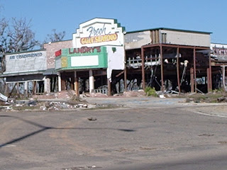
Pictures:
1: Landry's Restaurant - Biloxi, MS
2: West side of Mobile Bay, AL
3: Storm Shutters on our Mobile, AL home

Eclipse Photos....Showers Return!


A very big "thank you" to Kathryn Harris of Hixson for sending in her photos of this morning's lunar eclipse. The eclipse was seen low on the western horizon, which may have been blocked by the local mountains and ridges for some of you. Those who did see it saw a nice treat just before sunrise. In case you missed it, don't worry, you will get another chance coming up in February.

Welcome back rainfall!!! Granted, the storms were just scattered in nature, but those if us that did experience rain received almost an inch of rain. The official reading at Lovell Field was 0.94 inches, but only 0.21" at the WTVC studios. before the storms arrived the temperature peaked out at 95 degrees. That means that 24 of the past 25 days have been 95 or higher...whew! Temperatures should take a break the next few days as we should see a daily round of afternoon t-showers. The best coverage should come on Thursday with a front slowly moving in.

Monday, August 27, 2007

Total Lunar Eclipse Tuesday Morning


You will have to get up early to enjoy this celestial treat. With a full moon in place, the moon will pass in the shadow of the earth which will block the sun's rays from reaching the moon. The end result will be a darkened, rusty colored moon which will be visible for almost 2 hours. The partial eclipse will begin at 4:51am, then enter the total eclipse phase from 5:52am-7:22am. The end partial phase will take place at 8:24am. unlike a solar eclipse, you do not need special tools or eye guards to view it. It will be visible with the naked eye, and even better through a telescope lens.

As I mentioned in an earlier posting, the Mars Email Hoax continues to generate calls and email. This Email sounds impressive, but it is a hoax. I am only repeating this because tonight is the night the Email mentioned. And, I just want everyone to realize that the rusty colored moon tonight is indeed the moon....and not Mars.

Friday, August 24, 2007

Another Record Falls


102 was the official high temperature in Chattanooga Friday which just nudged out the old record of 101 set in 1968. The record streak of now 21 days 95 degrees or higher continues and we are still on pace for the hottest August ever with an average temperature of 86.2 degrees.

Thunderstorms made a return to the area. Some were severe with marble size hail reports from Cleveland and heavy rain in many spots. The rain helped cool things off for some of the high school football games, but other game sites were still hot and dry. The pattern that we saw Friday should repeat itself for Saturday as thundershowers once again pop up. Afternoon temps should stay below record levels Saturday, but still be plenty hot in the upper 90s.

Thursday, August 23, 2007

Only the Records Are Falling!

Not only was a daily record high set in Chattanooga, it was within 1 degree of tying the all time record high. 105 was recorded at Lovell Field at 2:26pm which surpassed the old record of 102 set in 1968. The all time record high is 106 set on July 28, 1952. We are also seeing other records fall. We are still on pace for the hottest August on record with an average temperature of 86 degrees far above the current record holder of August 1993 with an average of 82.5. We have experienced 20 straight of temperatures above 95. The old record was 18 days in late August and early September of 1993. We could set another record Friday with highs around 100. The record is 101, so another record is within reach.

Wednesday, August 22, 2007

Yet Another Record High!

Once again, record heat was experienced across the Tennessee Valley. The recorded high temperature at Lovell Field was 103 degrees, which surpassed the old record of 100 set in 1983. We are still on pace for the hottest August on record with an average temperature of 85.9 degrees. The current record belongs to August 1993 with an average of 82.5, so we are currently well above the number. August 2007 could also go down as the hottest month ever recorded in Chattanooga.

Now for some "cool" thoughts to ease the heat:

- Today's Record Low: 55 (1956)....It is possible to actually have cooler weather this time of year!

- Autumn is only 31 days away

- The average date of the first frost is October 21st (just 2 months away)

- Yesterday's high temperature at Mt. LeConte, TN (elevation 6600 ft) was only 72.

Tuesday, August 21, 2007

Felix Forming?


August 15-October 15 is typically the busiest 2 months of the hurricane season and this year has started heating up right on time. Dean reached the Top 10 list of strongest recorded hurricanes before plowing into the Yucatan. Cancun was spared the worst with Chetumal to the south taking the brunt of the storm. Dean should move back over water in the southern Gulf (Bay of Campeche) before making a second landfall. The second landfall in Mexico will be far less severe than what occurred on the Yucatan. As Dean begins moving away, another system is being watched well east of the Bahamas. A tropical wave interacting with an upper low is tightly clustering t-storms and upper level conditions are beginning to improve for some development over the next couple of days. The NAM, North American Model puts this system near the Bahamas over the weekend with a continued westerly movement. The tropical model suite (see image above) also favors a westerly path with some slow development. So, "Felix" could be on the horizon.

Dean Makes Landfall

HURRICANE DEAN ADVISORY NUMBER 33
NWS TPC/NATIONAL HURRICANE CENTER MIAMI FL AL042007
400 AM CDT TUE AUG 21 2007

...CATEGORY FIVE HURRICANE DEAN MAKES LANDFALL ON THE EAST COAST OF
THE YUCATAN PENINSULA OF MEXICO...

AT 400 AM CDT...0900 UTC...THE GOVERNMENT OF MEXICO HAS REPLACED THE
TROPICAL STORM WARNING AND HURRICANE WATCH WITH A HURRICANE WARNING
FROM WEST OF CHILITEPEC TO VERACRUZ MEXICO.

REPORTS FROM AN AIR FORCE HURRICANE HUNTER PLANE INDICATE THAT THE
EYE OF DEAN MADE LANDFALL ON THE EAST COAST OF THE YUCATAN
PENINSULA NEAR COSTA MAYA OR MAJAHUAL AROUND 330 AM CDT. THIS
LOCATION IS ABOUT 40 MILES...65 KM...EAST-NORTHEAST OF CHETUMAL
MEXICO

MAXIMUM SUSTAINED WINDS ARE NEAR 165 MPH...270 KM/HR...WITH HIGHER
GUSTS. DEAN IS A CATEGORY FIVE HURRICANE ON THE SAFFIR-SIMPSON
SCALE. ALTHOUGH SOME WEAKENING IS FORECAST AS DEAN CROSSES THE
YUCATAN PENINSULA...DEAN IS EXPECTED TO MAINTAIN HURRICANE STRENGTH
THROUGHOUT THE NEXT 24 HOURS.

Monday, August 20, 2007

Dean Reaches Category 5 Strength


HURRICANE DEAN ADVISORY NUMBER 32
NWS TPC/NATIONAL HURRICANE CENTER MIAMI FL AL042007
1100 PM EDT MON AUG 20 2007

...EYE OF POTENTIALLY CATASTROPHIC HURRICANE DEAN JUST A FEW HOURS
FROM LANDFALL ALONG THE EAST COAST OF THE YUCATAN PENINSULA..
MAXIMUM SUSTAINED WINDS ARE NEAR 160 MPH...260 KM/HR...WITH HIGHER
GUSTS. DEAN IS A POTENTIALLY CATASTROPHIC CATEGORY FIVE HURRICANE
ON THE SAFFIR-SIMPSON HURRICANE SCALE. LITTLE CHANGE IN STRENGTH
IS EXPECTED PRIOR TO LANDFALL ON THE EAST COAST OF THE YUCATAN
PENINSULA. ALTHOUGH SOME WEAKENING IS FORECAST AS DEAN CROSSES THE
YUCATAN PENINSULA...DEAN IS EXPECTED TO MAINTAIN HURRICANE STRENGTH
THROUGHOUT THE NEXT 24 HOURS.

Former Chattanoogan riding out Dean in Cancun

Former Chattanoogan Gene Hilton now lives in Cancun, Mexico. I spoke with him Monday evening and he gave this account of the conditions as Hurricane Dean moves in. "The outer bands have moved in and the conditions have worsened, we are hunkered down in our condo for the storm." Hilton said that he and his wife have taken the proper steps to protecting their condo with storm shutters in place. He was also amazed that people were still on the streets as the outer bands moved in at 9pm local time in Cancun.

Dean Heads For Mexico...Record August Heat Locally


After a weekend visit to Jamaica, Dean should continue a westward motion passing south of the Cayaman Islands. This will also include a pass over the warmest waters of the Caribbean Sea and allow for more intensification possibly to Category 5 strength. The Mexican coast of the Yucatan Peninsula is the next land mass to be affected. Popular tourist sites like Cancun and Cozumel will be affected by the outer bands of Dean, while the center will pass south of there. Tulum, a city on the coast by south of Cancun, could be near the area hardest hit. Tulum took a devastating blow from Hurricane Wilma in 2005 and Dean could be another setback. Once Dean passes over the Yucatan, there should be significant weakening and even a pass back into the warm waters of the Bay of Campeche will still not allow Dean to return to its prior strength before a second landfall in Mexico.

Locally, the heat continues and we are well on our way to setting the record for the all time hottest August. Here is where we stand so far, through Sunday the average temperature for the month was 85.8 degrees. The current record holding August was in 1993 with an average temperature of 82.5 degrees. Do the math and you realize that this August could shatter the old record by leaps and bounds! As I have mentioned in past posts, the reason for this extreme heat not only lies with upper atmospheric conditions, but the extreme drought. The lack of soil moisture and subsequent moisture in the air allows for higher surface heating temperatures. It's kind of like baking some cookies with dough that is not moist enough....they will burn in a short period of time. Our humidity levels should only slowly move up over the next few days, and a few isolated showers are possible. Air temperature readings should remain in the upper 90s with a visit to 100 not impossible during the work week. Some relief may be in sight for next week. An upper level trough has been indicated by several long range computer model runs. While the timing is differnt with each model run, the models are consistent in indicating that suh a trough should develop somewhere in the 6-10 day time frame. This could take a huge chunk out of the heat and even swing some showers/thunderstorms our way with the passage of a cold front. The latest 6-10 day outlook from the Climate Prediction Center is starting to show signs of the changes ahead. Again, we have another very hot week ahead, but some signs of change are slowly emerging for the following week.

Friday, August 17, 2007

Jamaica Topping "Dean's" List


Major Hurricane Dean could be on a collision course with Jamaica by Sunday. Dean is located in an environment which should sustain the current strength along with intensification. It is possible for Dean to be a strong Category 5 hurricane when it arrives on the Jamaican coast. After Jamaica, the Cayman Islands and Cancun/Cozumel will be on the radar for a visit from Dean. The longer range outlook for the United States would favor a landfall from the south Texas coast southward to along the Mexican coast. As far as Dean's strength at that point will depend on its rendezvous with the Yucatan Peninsula. A longer time over land should allow the storm to weaken from 4 or 5 strength. Once this occurs to a storm it will make it much harder for the storm to regain its once powerful strength. A shorter time spent over the landmass of the Yucatan will mean that Dean could sustain its strength.
Our region should not have any effects at all from Dean. Most, if not all of the moisture should still well south of our region, and the hot/dry pattern will continue.

Thursday, August 16, 2007

Another Day, Another Record......A Look Back At Forecast


Today's official high temperature at Lovell Field was 104 degrees which surpassed the old record of 101 set back in 1954. It was the second straight day of record breaking temperatures. The last time Chattanooga recorded a high of 104 was on July 29, 1993. Today was not far from the all time record of 106 set in late July of 1952. The Exceptional Drought that we are experiencing has everything to do with the fact that temperatures are extremely high. A lack of soil moisture results in lower air humidity values and hotter temperatures. It's a pattern that is often seen in the southwestern US and not here in the southeastern US. If you have been a regular reader of my blog you might recall my Summer outlook from May 10th which told of the possibility that the drought could lead to extreme heat. Here is an excerpt from that column:

(From May 10th Blog Entry): The Drought Monitor closely studies the entire country and determines the severity of dry spells. These drought conditions leading into the summer, could cause a warmer than normal summer.

A normal rain pattern would have led to an ample ground supply of water. Moisture in the top layer of the soil can serve to keep temperatures in check through evaporation. Granted, the added moisture in the air provides a muggy feeling, the evaporation and evapotranspiration process will keep air temperatures near seasonal levels. A parched, dry soil layer will absorb and retain the heat, therefore warming the air and leading to above normal temperatures. Again, on the flip side, it is not as humid, but very hot. The 2 week temperature trend keeps us in the above normal category. So, unless a wetter than normal pattern begins to take hold in June, we could be in for a hot summer.

Tropical Update: Dean is now a hurricane and should become a major one as it races through the Caribbean Sea. It "could" affect Jamaica and the Cayman Islands over the weekend and potentially Cancun by Monday. The forecast cone is close to the consensus of computer model guidance which indicates a west-northwest movement. At the current time, the western Gulf looks to be the region of highest risk from Dean next week. If this occurs, the Tennessee Valley should have no impacts at all and the heat will continue.

Wednesday, August 15, 2007

102 Today Shatters Old Record

We expected a record high today and did it ever live up to the billing. The old record high for this date is 99 back in 1980. The official high was 102 at Lovell Field which raises the bar as a new record for this date. It is the hottest that we have been since 2000. And, the last time we were higher was in July 29, 1993 when we topped out at 104. The all time record high for Chattanooga is 106.

Tuesday, August 14, 2007

Who Will Be On Dean's List?...TD5 Develops in Gulf


At 11pm, the National Hurricane Center assigned Tropical Depression 5 status to the system in the Gulf. It is heading west and should affect the Texas coast by Thursday as a moderate tropical storm. Our local area will not see any affects from this system.
I will give credit where credit is due for the first headline. Our news producer Dan Lehr posed that question to me as to where "Dean" might go. TD4 was upgraded to Tropical Storm Dean Tuesday morning as it is gradually gaining strength. It could become the season's first hurricane by the end of the week. The tropical season is almost right on schedule as today marks the average date of the first hurricane of the season. It is still too early to say where Dean might end up. But, the 5 day forecast cone shows a slight nudge west-northwest which is consistent with most of the computer model guidance. By Day 5, there could be a gap between pressure ridges that could allow this west-northwest turn. All the while, the environment for strengthening should continue. The one big question mark remaining is what path will it take in the northeastern Caribbean. A pass over the higher terrain of Hispanola has been known to shred apart developing storms. We will just have to see if Dean tries to become a mountain climber, or skirts around and strengthens near the Florida Straits and Bahamas. Only time will tell.

Monday, August 13, 2007

TD4 and Maybe More!


Right on schedule, the tropics have awakened and a pulse of activity is about to begin. Tropical Depression 4 should soon be upgraded to a tropical storm (Dean) and eventually a hurricane as it nears the Caribbean Sea. It is too early to say where this storm might end up, but a visit to the southern Gulf is possible into next week. Speaking of the Gulf, another flare up of activity could be underway near the Yucatan, Pressures are falling in that region and the parent tropical wave is drifting west. Should a system form, it could become the 5th tropical system of the season and should drift west toward the Texas/Mexico coast. More details to follow in the days ahead!

Sunday, August 12, 2007

Here Comes The "Mars" Email Again!


Every August, I start receiving email from viewers anxious to know more about the "Mars Spectacular". Most of you who have emailed me are wondering if this is true, or is it another urban legend. The email message that is circulating around offices and homes across the web claims that on August 27th Mars will be as big as the moon in the sky. Simply put, this is yet another urban legend. There is a small grain of truth to how the story got started. Mars "did" reach its closest point to earth on August 27, 2003. At that time, Mars appeared 6 times larger than it usually does. This means that instead of a "tiny" red dot in the sky, it was briefly a "small" red dot in the sky. If Mars ever did appear as large as the full moon, we would have all sorts of gravity and tidal issues. There will be a large bright object in the sky on the nights of August 27 and 28, but that will be the Full Moon.....not Mars!

The email is fascinating and "scientific" sounding in its context, but alas it is just another email that needs to be deleted instead of forwarded.

Friday, August 10, 2007

Meteor Shower This Weekend


We are in dire need of rain, and it will be several days before showers return to the forecast. However, there is one shower that we can always count on every August, the Perseid Meteor Shower. We should have nearly perfect conditions for this event which peaks Saturday night just after midnight. With a New Moon phase currently, the darkened sky will make the perfect back drop for the Perseids as they streak across the sky. Also, with dry air in place, there will not be any haze to block the view. The Perseid Meteor shower is a great astronomy event which the whole family can enjoy without the need of binoculars or a telescope. You will want to be in an area away from the city lights and you should be able to see up to one meteor per minute. Again the peak time is just after midnight Saturday night through the predawn hours. The next several nights through next week will still exhibit some meteors, but not at the rate that will be possible Saturday night. Enjoy!

Thursday, August 9, 2007

100 Degrees Thursday...But Not A Record

Whew....Yes, it was a scorcher Thursday as the temperature reached the expected high of 100. While it was a rare day of triple digit heat for the Tennessee Valley, it was not quite a record. The record high for Thursday was 103 degrees which was set in 1980. Here are some other high temperature readings from Thursday around the region:
Nashville: 104
Atlanta: 103
Rome, GA: 102
Huntsville, AL: 101
Dalton, GA: 97
Ft Payne, AL: 97
Murphy, NC: 94
Crossville, TN: 93

The Heat Index peaked at 105 Thursday afternoon, with the 100 degree heat and humidity in the 35% range. Thursday's high of 100 marked the first time we have reached the century mark since August 4, 2006. And, it was only the second time in the past 5 years we have recorded triple digit heat. I did a little research to see how many times we have recorded 100 degrees or higher since 1980. The results might surprise you. Even though average temperatures have risen slightly over the past couple of decades, the number of days 100 or above have dropped off. Here is what I found:

Number of Days 100 degrees or higher per decade:

1980 to 1989: 24 Days 100 or higher
1990 to 1999: 17 Days 100 or higher
2000 to August 9, 2007: 3 Days 100 or higher

The overall pattern will change little over the next few days. Morning temps may be slightly cooler from 70 to 72, but afternoon readings should still average above 95 through early next week. This pattern could continue for the next 2 weeks. The only way we might be able to see a bust in this pattern and get more rainfall is dependent on any tropical development. The European and Canadian models are indicating some rumblings beginning in the tropical breeding grounds and a pulse of activity could be just around the corner. The Caribbean Sea and extreme southern Gulf could be areas to watch by the weekend and early next week.

Wednesday, August 8, 2007

Heat Advisory Through at Least Thursday


99 was the official high temperature in Chattanooga on Wednesday. The record high was set in 1980 with 102 degrees, so no record Wednesday, but still well above normal. The Excessive Heat Advisory remains in effect through 8pm Thursday and could get extended into Friday. The upper level ridge that has dominated our region lately will shift west through Saturday. This could bring about a "slight" change in temperature as we go through the weekend. "Slight" meaning 3-5 degrees difference. The most noticeable change will be during the morning hours. Morning temperatures will average in the upper 70s Thursday morning, but ease back to near 70 for the weekend. Afternoon high temperatures should still average well above normal, but stay in the middle 90s as opposed to near 100 Thursday. So, it's not much of a change, but it's the best we can hope for over the next few days. Showers chances will remain slim and limited to only a few isolated showers during the weekend.

Tuesday, August 7, 2007

Excessive Heat Advisory Through Thursday

...HEAT ADVISORY IN EFFECT FROM 1 PM EDT /12 PM CDT/ WEDNESDAY TO
8 PM EDT /7 PM CDT/ THURSDAY...

THE NATIONAL WEATHER SERVICE IN MORRISTOWN HAS ISSUED A HEAT
ADVISORY...WHICH IS IN EFFECT FROM 1 PM EDT /12 PM CDT/ WEDNESDAY
TO 8 PM EDT /7 PM CDT/ THURSDAY.

HEAT INDEX VALUES WILL REACH 100 TO 105 ACROSS SOUTHEAST TENNESSEE
DURING THE AFTERNOON.

A HEAT ADVISORY MEANS THAT A PERIOD OF VERY HOT CONDITIONS IS
EXPECTED OR OCCURRING. HOT TEMPERATURES AND HIGH HUMIDITY WILL
COMBINE TO CREATE A SITUATION IN WHICH HEAT ILLNESSES ARE
POSSIBLE. AVOID PROLONGED WORK IN THE SUN OR IN POORLY VENTILATED
AREAS...DRINK PLENTY OF WATER AND OTHER NON-ALCOHOLIC BEVERAGES...
AND SPEND AS MUCH TIME AS POSSIBLE IN AN AIR CONDITIONED
ENVIRONMENT.

Friday, August 3, 2007

Hurricane Forecast Remains Above Normal


The hurricane forecast team of Dr. William Gray and Phillip Klotzbach at Colorado State University have released their forecast for the remainder or "peak" of the hurricane season. Each season, regularly scheduled updates are released to apply June and July weather conditions to the forecast for the remainder of the season. Their newest update includes a slight reduction from the 17 expected named storms in their June 1st forecast. However, the overall numbers remain well above normal. As of August 2, there have been 3 named storms. Their forecast calls for an additional 13 named storms, with 8 of those possibly becoming hurricanes. Of those 8 hurricanes, 4 could become major hurricanes (category 3 and above). This means that the season total could be between 15-16 named storms. The Gray/Klotzbach team expects a 44% chance of a major hurricane affecting the US Gulf Coast (the normal risk is 30%). The U.S. East Coast is given a 43% risk of a major hurricane making landfall. One very important factor to remember about these forecasts is that the "number of storms" is not the main factor. The fact that they are expecting 13-15 storms indicates a value that is above the normal trend of 10 named storms per year. So, they are favoring another above normal season as we head into the most dangerous part of the season.

The reason behind their slight reduction in the number of expected storms is due to the fact that the sea surface temperatures (SSTs) in the tropical Atlantic have cooled during July. However, a lack of EL Nino resulting in cooler waters off South America may mean less wind shear in the tropics to prevent storm formation. Conditions such as this have led to busier than normal seasons. And, even though the tropical Atlantic breeding ground is slightly cooler, The Gulf waters are above normal, thus the above normal risk to the Gulf states.

So, what does this mean for the Tennessee Valley? Well, in some of my earlier postings I have stated that an active Gulf season can help produce above average rainfall locally depending upon the path of the storm. Since 1995, storms such as Opal and Ivan brought soaking rains locally, but also unfortunately produced some wind damage. Atlantic storms tend not to bring much rain our way. We are often times on the drier west side of storms that make landfall along the Carolina coast.

Here is a link to the full report: Gray/Klotzbach Hurricane Forecast Update

Wednesday, August 1, 2007

July 2007 Recap

July 2007 was just what the doctor ordered! Suffering through the worst drought in decades, the weather pattern during July was a nice change. Let's start with the temperatures. The average temperature was 78.3 degrees, which was 1.3 degrees below normal. The coolest morning was late in the month on the 21st with 62 degrees. We had 14 mornings with temperatures in the 60s. The hottest temperature was 93 degrees which occurred on the 8th and 9th. Now, for the most important statistic of the month, rainfall. 7.18 inches of rain was recorded at Lovell Field, which was 2.45 inches above normal. July was the wettest month of 2007 so far. In fact, July was the wettest month in 32 months. You have to go back to November 2004 to find a wetter month in Chattanooga, when 6.60 inches of rainfall was received. The first day of August continued the "wet" trend, with 0.53 inches recorded. Our yearly deficit still stands at over 12 inches, which will be hard to overcome. However, more months like July will help ease us out of the drought in the long term.

Tuesday, July 31, 2007

TD3 Becomes Tropical Storm Chantal...No Threat to U.S.


Chantal is no threat to the U.S. It is moving rapidly northeast as it is being absorbed by a cold front. Chantal should begin to lose its tropical characteristics and become "extratropical". Even though it will not be "tropical", it will still gain a little strength as it passes off the coast of Newfoundland and across the north Atlantic. This storm will be a menace to shipping through the end of the week and the weekend. The National Hurricane Center has issued the last advisories on Chantal as of 11pm Tuesday.

Another area being watched for possible development is a tropical wave east of the Windward Islands. The system remained disorganized Tuesday, but environmental conditions appear favorable for future development. Hurricane Hunter aircraft is scheduled to investigate this system, if necessary Wednesday.

A non tropical low pressure system is off the Carolina coast, and should remain offshore as it moves northeast.

Monday, July 30, 2007

Tropics Starting to Stir


It comes as no surprise that activity is beginning to stir in the tropical regions of the western Atlantic. As i mentioned in my post from last week, the start of August signals the start of the busier time of year for tropical weather. There are two features being watched. The first is Tropical Depression 3 east of Bermuda. It is an area of low pressure which has slowly become more organized. Its window of opportunity for development to a tropical storm is starting to close as this low should get absorbed by a cold front and get shoved rapidly northeast off the US coast. It could affect the Canadian Maritimes as a tropical storm. The second area to watch is a tropical wave that is getting better organized a couple of hundred miles east of the Lesser Antilles. Computer model guidance is suggesting a general west-northwest movement as it moves into the warm waters of the Caribbean Sea. Some further development is possible.

Sunday, July 29, 2007

Record Breaking Rainfall Saturday

2.74 inches of rain was recorded at Lovell Field in Chattanooga on Saturday. That total now stands as a record for the most rain received for a July 28th. The record rainfall also boosted our monthly rainfall total for July to 7.18 inches, which is 2.86 inches above normal for the month. We still have a huge deficit for the year, but it has been whittled away to 12.23 inches. However, since June 1, we have experienced above normal rainfall with 9.20 inches received. that total is 0.89 inches above normal. July has been a terrific start to the second half of the year concerning rainfall.

Wednesday, July 25, 2007

Hurricane Season Has Only Just Begun!


Hurricane season begins every year on June 1. But, the "real" hurricane season really kicks off August 1. If a hurricane season was compared to an NFL season, we would still only be in the preseason. I spent the last 8 hurricane seasons on the Alabama/Florida Gulf coast. I was able to forecast and experience some of the most destructive hurricanes in US history (Ivan and Katrina). Granted, we did have a few early season hurricanes in June and July (Dennis in 2005), but the true meat of the season gets underway after August 1. I have already seen a few national news reports that are a little premature and impatient with their reporting claiming that the 2007 hurricane season is a bust. The hurricane season is a long way from being over, and here are some stats to drive home this point.
During an "average" hurricane season, the first named storm usually occurs by July 10. For 2007, we are already ahead of schedule with Tropical Storm Andrea occuring in May and Tropical Storm Barry on June 1-2. The first hurricane of an average season should occur by August 14th, which is still 3 weeks away. The first major hurricane of an average season typically occurs by September 3rd (6 weeks from now). The statistical peak of the season is not until September 10th. So, as these statistics show, its way to early to call the 2007 season a bust. The extremely busy 2004 season really did not get cranked up until the second week of August with Bonnie and Charley hitting Florida just 2 days apart.
The available heat potential in the Gulf is above normal, but lower in the western Atlantic. So, the Gulf coast has conditions which are ripe for sustaining a developed storm should one move into the Gulf basin. The position of the Bermuda High off the US east coast is providing an alley way which still tends to favor Florida and the central/eastern Gulf for tropical activity.
So, as the "preseason" ends and the busy part of the season kicks off, you can depend on the Storm Track 9 team to keep you posted of storms that could affect your beach plans and those that could have some local impact.

Interesting Editorial from the Wall Street Journal written by hurricane expert Dr. William Gray - (Link)