Thursday, May 31, 2007

Smoky Locally.....Tropics Abuzz


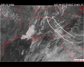
Yes, the smoke in our local region is from the large wildfires in south Georgia and north Florida. A strong high pressure system aloft is trapping the smoke and haze locally creating poor visibility and air quality. Because the "High" has shifted east a bit, it places our region in direct line of the southeast wind which is transporting the smoke to the Tennessee Valley. We should again see smokey and hazy conditions Friday, with some improvment over the weekend as some hit and miss showers return.


The official start of the 2007 hurricane season is Friday, and the tropics are already a little interesting. A broad region of low pressure off the Yucatan coast is straddling the southern Gulf and northwestern Caribbean Sea. This "low" should drift north into the southern Gulf through Friday. Strong wind shear across the western Gulf should push this low north, then northeast. This means that our region should not see any moisture come our way. But, Florida could really benifit with several inches of rain expected over the weekend as this low moves across the peninsula. As far as any tropical development, it is possible, but it will mainly just be a heavy rain producer for Florida. Should it develop into a tropical storm, the name would be Barry.
Be sure to watch the latest Webcast for a full explanation of how the smoke has moved our way from south Georgia (link)
Don't miss the Blue Moon tonight. It will not be "blue" in color, but it will be the second full moon of the month. The Old Farmer's Almanac definition of a Blue Moon is 2 full moons during a calendar month, which applies to tonight's event. However, an old copy of another type of farmer's almanac from Maine tells a different story of the origin of the Blue Moon. Here is a link to an interesting alternate definition (link). Special thanks to one of our viewers, Henry Kuhlman for sharing this article!

Wednesday, May 30, 2007

Pattern Change Coming?

For the past few days, I have seen some consistency in the long range computer models. I will provide a link to this data at the end of today's posting. Both the European and American models are showing a weakening of the persistent upper level ridge of high pressure that has kept our region and most of the US southeast warm and dry this month. It is worth noting, that since the start of 2007, every-other month has experienced a prolonged period of high pressure ridging only to be followed by a weakning of the ridge the next month. January and March both had weeks of warm and dry conditions. February and April were cooler and "slightly" wetter (not by much though). So, as we enter the month of June on Friday, the pattern change could begin.

With a weakening of this high pressure ridge, an upper level trough will replace it. An upper level trough can help destablize the air enough to help trigger some afternoon showers locally. So, this pattern is not a drought buster. But, at the very least, could help stop the persistently dry pattern we have experienced for much of May. It will also become muggier with the increase in humidity, so morning temps may not be as comfortable as they have been lately. The long range projections do indicate that we may stay with this pattern the first 10 days of June. I will keep you posted.

Computer Model Links: GFS (American Model): Link
ECMWF (European Model): Link

Local Web Drought Headlines: Hiwassee Recreation Effected by Drought (Link)
Great Arictle on the "Hows" and "Whys" of Drought (Link)
Drought Update from The Peach State (Link)

Please be sure to stay up to date with local conditions on Newschannel 9. You can view today's webcast and live radar at www.newschannel9.com.

Monday, May 28, 2007

Drought at Extreme Level....Any Relief?

The current drought conditions that we are experiecning is declared as "Extreme" by the US Drought Monitor. A persistant high pressure system at the surface and aloft has kept our pattern consistently dry. The next few days continue to look dry, but a slight pattern change by the weekend could allow for a return of some scattered showers locally. The 6-10 outlook (2nd image) indicates the slightly above noraml rainfall chances by the weekend and early next week. Granted, it is not enough to wipe out the drought conditions, but it could provide our lawns and gardens with a much needed drink of water.
Please be sure to view my latest Webcast which will describe the upcoming 7 Day weather pattern changes (Webcast Link) .

Tuesday, May 22, 2007

Busy Hurricane Season Expected


For the first time in 9 years, I will not be a coastal resident when the hurricane season begins. Trust me, I am happy to be back home and an "inland" resident. From 1998-2006, I served as Chief Meteorologist at WPMI Pensacola/Mobile. I have always had a deep interest in tropical meteorology, and I was able to witness first hand some of the most destructive hurricanes in our nations history. In one calendar year from September 2004-August 2005, I was affected by Hurricanes Ivan, Dennis and Katrina. Ivan and Katrina rank in the top 10 most destructive storms in US history. Ivan was bad, but Katrina was horrific. We suffered wind damage to our roof and tree loss. Plus, no power or gas for days with 90+ degree heat. But, at least I still had my home, far too many people in my part of the Gulf coast were not so fortunate. So, I had no room to complain but be very thankful. Even through all of those storms, my interest and fascination is still there. I was able to get a hands on study of tropical storms and hurricanes that went far beyond what was taught to me in college years ago. So, as the 2007 season begins, I will watch it unfold with the same interest, but also with a greater feeling of safety being hundreds of miles inland.

The 2007 NOAA forecast is in agreement with many of the other early season forecasts. An above normal season looks to be in the cards once again. In fact, this years conditions are very similar to the 2004 season. Sea surface temperatures (SST's) are warmer than average in the hurricane development region. But, that's not the only ingredient. What also exists are lower than normal surface air pressures and high pressure aloft. That vertical make up of the atmosphere is prime for development. The easterly trade winds are also light which will allow growth by reducing wind shear that can usually rip up a storm during the early stages of development. NOAA expects a 75% chance of an above normal season. NOAA is projecting 13-17 named storms, 7-10 of those becoming hurricanes and 3-5 of those hurricanes becoming major (category 3 or above) storms.

What does this mean for the Tennessee Valley? Well, an increase in Gulf activity could lead to some drought busting rainfall should the landfall path move far inland. Past storms such as Opal (1995), Georges (1998) and Ivan (2004) brought heavy rain to our area. On the flip side though, Opal and Ivan brought wind damage locally, but far far less that what was experiecned on the Gulf coast. So, what may be bad news for the coastal regions, could be a little "good" news for us should the rainfall prospects pan out. Only time will tell though!

Here is a link to the list of names for the 2007 season and beyond...Is your name there? (link) Remember, Andrea has already been used for the Subtropical Storm that formed earlier this month. So, Barry is the next name on the list.

Monday, May 21, 2007

Summer Outlook...Hot


The Climate Prediction Center has released its outlook for the next 90 days and it looks hot. Please refer to my May 10th posting about why I believe that the drought we are experiencing could lead to a hotter than normal summer. The rainfall expectations are mixed with our region being in the "EC" category. This means that we have equal chances of being above or below normal. Again, I believe the upcoming tropical season will determine how wet we will be this summer and early fall.

Weather Web Headlines:
Wildfires affecting Smoky Mountains near Cades Cove (link)
Clear nights are perfect for star gazing, here is a great link that shows what's seen in our local skies (link)

Friday, May 18, 2007

Beautiful Weekend Ahead


Temperatures Friday morning were quite cool across the Tennessee Valley. Here is a sampling of the morning readings:

Chattanooga: 53
Dalton, GA: 50
Crossville, TN: 44
Murphy, NC: 42
Ft Payne, AL: 41
Robbinsville, NC: 37
Newfound Gap (TN/NC Border 5000ft elevation): 34

Mount LeConte, TN (6400 ft - Smokies): 29

With a clear sky and lighter breeze through Saturday morning, temperatures across our region should reach the lower/middle 40s. The record low temperature for Chattanooga Saturday morning is 40. The weekend should exhibit some warmer temperatures each afternoon with middle 70s Saturday and around 80 Sunday. Temperatures should warm back above normal next week with a slight chance of showers by Wednesday. Have a safe weekend!!!!!


Web Weather Headlines:

Drought & Late Chill Causing Bear Problems in Blairsville (link)
Hurricane Katrina's 2 Eyewalls - (A great story by a friend of mine in Mobile, AL) - (link)


Thursday, May 17, 2007

Mid-May Chill


A chill in mid May is often called "Blackberry Winter". Granted, this cool spell is nowhere near the record cold of April, but it is below normal. Our normal low temperature this time of year is 56 degrees, we should be about 10 degrees below that value Friday through Sunday morning. Thursday morning was just the start of the cooling trend, here is a sampling of this morning's lows:

Ft Payne, AL: 41
Robbinsville, NC: 41
Crossville, TN: 43
Murphy, NC: 46
Dalton, GA: 50
Chattanooga: 52

Most areas in the lower elevations should see temperatures in the upper 40s by Friday morning. The mountain tops should have readings in the lower 40s and even a few upper 30 degree readings in the highest elevations of the Blue Ridge Mtns (Big Frog Mtn, Grassy Mtn). Morning temperatures over the weekend should be in the middle 40s valley locations and near 40 mountains. The weekend looks outstanding with sunshine and warm afternoons from 75 to 80 degrees.

Today's Weather Web Headlines:
Smoke from South Georgia Wildfires Reaches Atlanta (link)
Improved Hurricane Monitoring this Season (link)
National Hurricane Center vs NOAA for Funding (link)

Please be sure to read my other postings from the past week regarding other weather headlines from around the Tennessee Valley.